No reviews yet for ArcGIS
ArcGIS OVERVIEW
ArcGIS from Esri is an integrated collection of geographic information system (GIS) software products for multiple platforms and promising standards-compliant handling of spatial analysis, data management, and location-based 3D data mapping.ArcGIS is a powerful mapping and analytics platform designed to help businesses to explore information and share location-based insights. The unique set of capabilities include; spatial analytics, mapping & visualization, 3D GIS, Imagery and remote sensing, Real-time GIS, and data collection & management.
ArcGIS FEATURES
ArcGIS PRICING
Starting Price : $99
ArcGIS SPECIFICATIONS
ArcGIS Deployment
Platform :
- Cloud Based
- SaaS
Installed :
- Windows
Mobiles :
- Android
- iOS
ArcGIS Supported Languages
- English
ArcGIS API
- Open API
ArcGIS Integrations
Ultimo
Concept3D
Citizenserve
ArcGIS Training/Resources
- Documentation
- Webinars
- Live Online
ArcGIS Customer Support
- Phone
- Live Chat
ArcGIS COMPANY DETAILS
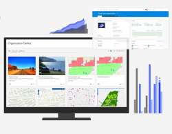
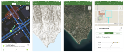
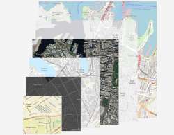
ArcGIS SCREENSHOTS

ArcGIS CATEGORIES LIST
Geographic Information Systems - GISArcGIS REVIEWS
No video reviews yet for ArcGIS
ArcGIS FAQs
Q. What are the key features of ArcGIS?
The key features of ArcGIS are:
- Image editing
- 3D imagery
- Task management
- 3D GIS
- Activity management
- Dashboard creation
- Drag & drop interface
- Mapping and Visualization
- Monitoring
- Geographic maps
- Graphical data presentation
- Activity tracking
- Spatial Analytics
- Engagement analytics
- Application sharing
- Single sign on
- Authentication
- Real time analytics
- Role-based permissionsUser activity monitoring
- Graphical user interface
- Multiple data sources
- Real-Time GIS
- Data mapping
- Spatial analysis
- Census data integration
- Secure data storage
- Data import
- User management
- Map sharing
- Automatic notifications
- Offline access
- Activity dashboard
- Map creation
- Customizable templates
- Data Collection and Management
- Data connectors
- Mobile integration
- Imagery and Remote Sensing
- Real time data
- Visual analytics
Q. How much does ArcGIS cost?
ArcGIS price starts from $99
Q. Which platform does ArcGIS support?
ArcGIS can be deployed on following platforms: Cloud Based, SaaS, Windows, Android, iOS
Q. Which languages does ArcGIS support?
ArcGIS supports following languages: English
Q. What type of API's does ArcGIS provide?
ArcGIS provides the following API's: Open API
Q. What are the integrations for ArcGIS?
ArcGIS can be integrated with: Ultimo, Concept3D, Citizenserve
Q. What training/resources does ArcGIS provide?
ArcGIS provides the following training/resources: Documentation, Webinars, Live Online
Q. What are the customer support options provided by ArcGIS?
ArcGIS customer support options are: Email, Phone, Live Chat